Guidance & Steering


Trimble guidance displays and steering solutions help you accurately monitor and map field information in real-time. Benefit from Trimble's industry-leading performance and reliability to complete field applications quickly and efficiently. With an array of functionalities and price points, you can select the combination that best fits your farming needs.

TMX-2050™

TMX-2050™ Display

TMX-2050™ Display

  • Screen size: 12.1” (30.8 cm)

  • Touchscreen

  • Video camera input: 1

  • Built-in GPS receiver: 1

  • GLONASS enabled

  • Assisted steering

  • Automated steering

  • Implement control

  • NextSwath end-of-row turn

  • Row guidance

  • ISOBUS/TUVR support

  • On-the-go VRA with GreenSeeker sensors

  • Water management

  • Field-IQ™ rate and section control

  • Yield monitoring

  • Precision IQ compatible

  • FmX Plus compatible

  • Trimble App Central

  • Internet connectivity

  • Learn more about the TMX-2050™ Display

  • Download the TMX-2050™ Brochure (PDF, Eng-US, 3.5 MB)

GFX-750™

GFX-750™ Display

GFX-750™ Display

  • Screen size: 10.1” (25.6 cm)

  • Touchscreen

  • Video camera input: 1

  • Built-in GPS receiver: 1

  • Assisted steering

  • Automated steering

  • Android operating system

  • Compatible with Precision-IQ™

  • Bluetooth and WiFi compatible

  • ISOBUS/TUVR support

  • GLONASS enabled

  • Field-IQ™ Basic rate and section control

  • RAM Mounting System

  • Trimble App Central

  • Internet connectivity

  • Learn more about the GFX-750™ Display

  • Download the GFX-750™ Datasheet (PDF, Eng-US, 149 KB)

GFX-350™

GFX-350™ Display

GFX-350™ Display

  • 7" (17.8 cm) high-definition color touch-screen display

  • Android-based operating system

  • Rugged construction for everyday field use

  • Compatible with NAV-500 and NAV-900 guidance controllers

  • ISOBUS task controller and universal terminal

  • Control up to 2 channels and 24 sections

  • Bluetooth and WiFi compatible

  • Learn more about the GFX-350™ Display

  • Download the GFX-350™ Datasheet (PDF, Eng-US, 180 KB)

Learn more about Trimble's Guidance & Steering


Other Products


AG-372 GNSS receiver

AG-372 GNSS receiver

A high-performance, dual-frequency GPS and GLONASS smart antenna receiver.

  • GPS and GLONASS enabled
  • Industry-leading 220 channels
  • Simulated radar speed output
  • L1/L2/L2C signal support
  • Learn more about the AG-372 GNSS receiver

AG25 GNSS Antenna

AG25 GNSS Antenna

High performance monitoring antenna, compact and housed in a rugged unit.

  • GNSS support including GPS, GLONASS, SBAS and L-Band
  • Enhanced ability to track lower elevation satellite signals
  • Built-in magnets for quick and simple installation
  • Can be installed permanently using the 5/8 inch thread
  • Improved multipath mitigation
  • TNC Connector
  • Compatible with the NetR9 Ti-M monitoring receiver
  • Learn more about the AG25 GNSS Antenna

AgGPS 542 GNSS receiver

AgGPS 542 GNSS receiver

An advanced, dual-frequency GNSS receiver, ideal for areas with irregular satellite reception.

  • Industry-leading 220 channels
  • Integrated 900 or 450 MHz radio
  • L1/L2/L2C/L5 signal support
  • Extended range and seamless coverage around obstacles
  • Learn more about the AgGPS 542 GNSS receiver

TDL 450L Radio

TDL 450L Radio

The TDL 450L radio is an advanced high-speed, wireless UHF data radio.

  • Full-function user interface for on-site set-up, configuration, and troubleshooting
  • Diagnostic data for solving signal strength challenges
  • Channel bandwidth options of 12.5 or 25 kHz
  • Extended range and seamless coverage around obstacles
  • Learn more about the TDL 450L Radio

Learn more about Trimble's Agricultural Products


Trimble Connected Farm

Postioning Services


Trimble has a positioning service to fit the accuracy level that’s right for your specific farming operation. Adding a Trimble RTX service to your Trimble guidance or steering system you can obtain repeatable accuracy from 20 inch (50cm) down to sub-inch (<2cm) year-over-year in every corner of your farm. Just choose the service that fits your farming needs.

CenterPoint RTX

  • Strip tiling, planting and seeding, spraying, spreading and more

  • High accuracy GNSS corrections accessible worldwide, no local base station or VRS network required

  • 1-inch (< 2.5 cm)

  • satellite communicationcell phone communication

  • Trimble AG-372, Trimble CFX-750™, Trimble FmX® , Trimble TMX-2050™, GFX-750™ / GFX-350™ NAV-900

  • Fast: Less than 2 minutes Standard: less than 15 minutes

RangePoint RTX

  • Broad-acre applications

  • Entry-level GNSS corrections,accessible worldwide, no local base station or VRS network required

  • 20 inch (50 cm) repeatable | 6 inch (15 cm) pass to pass

  • satellite communication

  • Trimble AG-372, Trimble CFX-750™, Trimble FmX® , Trimble TMX-2050™, GFX-750™ / GFX-350™ NAV-900

  • Less than 5 minutes

ViewPoint RTX

  • Broad-acre applications

  • Entry-level GNSS corrections,accessible worldwide, no local base station or VRS network required

  • 12 inch (30 cm) pass to pass

  • satellite communication

  • Trimble AG-372, Trimble CFX-750™, Trimble FmX® , Trimble TMX-2050™, GFX-750™ / GFX-350™ NAV-900

  • Less than 5 minutes

CenterPoint VRS

  • Drainage, drip irrigation, land leveling, strip tiling, planting and seeding, spraying, spreading and more

  • Instant access to high accuracy real time kinematic (RTK) corrections for automated guidance operations. Supports RTCM data format

  • 1-inch (< 2.5 cm)

  • cell phone communication

  • Trimble AG-372, Trimble CFX-750™, Trimble FmX® , Trimble TMX-2050™, GFX-750™ / GFX-350™ NAV-900

  • Less than 5 minutes

Orthman take pride in helping producers improve yields and preserve soil with equipment that works hard season after season. Nothing else is built like an Orthman and that's why Orthman equipment is A Tough Act to Follow.

Bedlisters

BedLister

The standard in bedding

  • Parallel Linkage BedLister
  • BedLister Roller
  • Rigid BedLister
  • Check Bedlisters

Cultivators

AG25 GNSS Antenna

Cutting Edge Cultivators

  • 8315 Cultivator
  • 8375 Cultivator
  • 8450 Cultivator
  • 9300 Cultivator
  • Check Cultivators

Planters

Planters

High performance planters

  • Narrow Row DR
  • 30" Row Planters
  • Wide Row Planters
  • Fully Mounted CSS
  • DR Twin Row Planters
  • Check Planters

Toolbars

Toolbars

Toolbar technology

  • Folding Toolbars
  • Stacking Toolbars
  • Check Toolbars

View all products at Orthman Logo linked to website


Drones for Agriculture


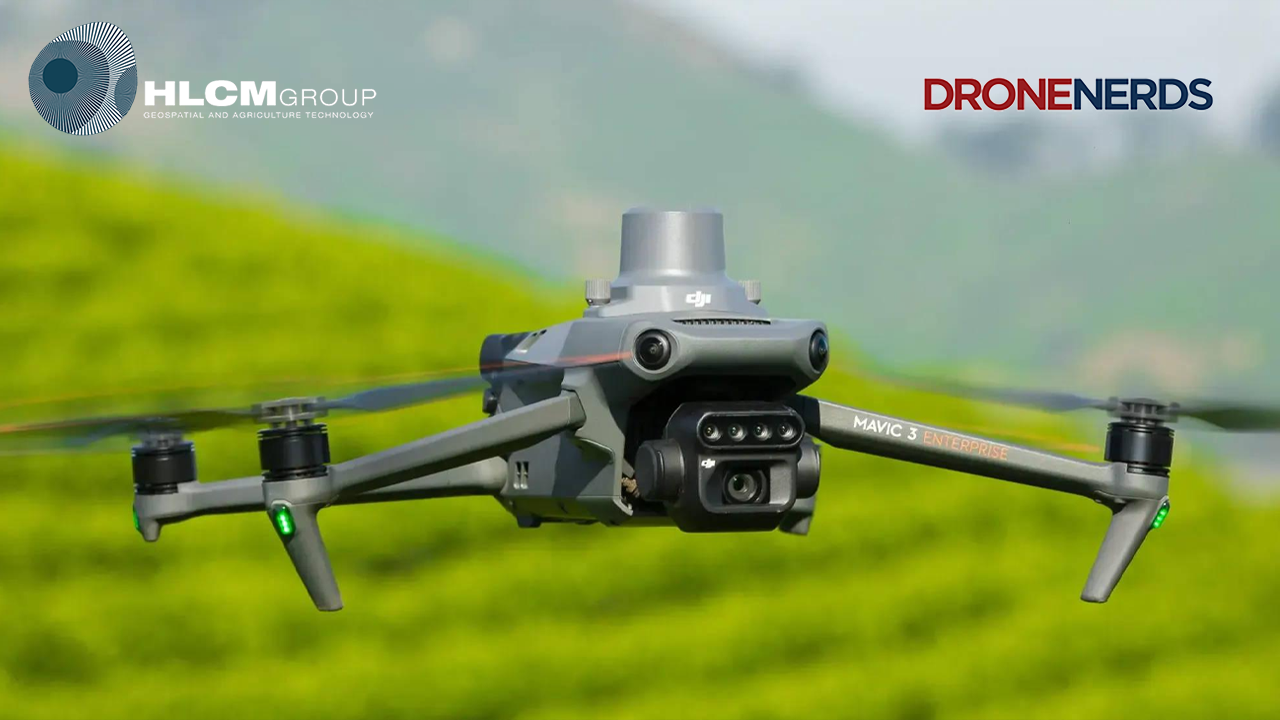
DJI Agriculture provide cutting-edge technology with innovative workflows, making farming more efficient than ever. The Agras series drones can spread seeds, fertilizer or other solid material. For precision Agriculture, combine the Agras with the Mavic 3 Enterprise Series RTK for mission planning and extensive plant health monitoring.

AGRAS T40

AGRAS T40 Drone

One for All

  • 40 kg Spray load

  • 50 kg (70L) Spread Load

  • Dual Atomized Spraying System

  • Active Phased Array Radar + Binocular Vision

  • Supports flight spraying/spreading and RC mapping

  • IPX6K Protection

  • Farmland: 21.3 hectare per hour

  • Orchards: 4 hectare per hour

  • Spreading: 1.5 tonnes of fertilizer per hour

  • Pair with Mavic 3 Enterprise Series for high precision farming

  • Learn more about the AGRAS T40

AGRAS T30

DJI AGRAS T30 Drone

A New Flagship for Digital Agriculture

  • 30L Spray Tank

  • Spray width: 9 meters

  • Up to 40L capacity Spreading System

  • Spread width: 7 Meters

  • Spherical Radar System

  • IP67 Water and Dust Resistance

  • Dual FPV Cameras for Monitoring

  • Field spraying efficiency up to 40 acres/hour

  • Spreading: 1 tonne of fertilizer per hour

  • RTK High Precision Operation

  • Learn more about the AGRAS T30

AGRAS T20P

AGRAS T20P Drone

Superior Performance at Best Value

  • 20 KG Spraying Payload

  • 25 KG (35L) Spreading Payload

  • Spray width: 7 Meters

  • Active Phased Array Radar + Binocular Vision

  • IPX6K Protection

  • Farmland: 12 hectare per hour

  • Orchards: 2.6 hectare per hour

  • Spreading: 1 tonne of fertilizer per hour

  • Learn more about the AGRAS T20P

AGRAS T10

AGRAS T10 Drone

The Ideal Drone for New Farmers

  • 8L Spray Tank

  • 8 KG Spreading Payload

  • Spread width: 7 Meters

  • Spherical Radar System

  • IP67 Water and Dust Resistance

  • Dual FPV Cameras for Monitoring

  • RTK High Precision Operation

  • Field spraying efficiency up to 14 acres/hour

  • Spreading: up tp 14 acres per hour

  • Learn more about the AGRAS T10

Plant and Crop Mapping


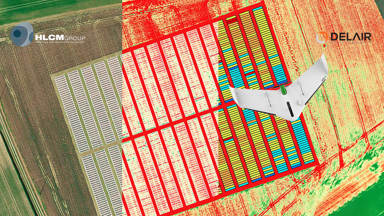
Throughout all growing seasons, multispectral imagery can be helpful for ag professionals by providing information invisible to the human eye across the electromagnetic spectrum. Having access to this data and the subsequently obtained Vegetation Indexes such as NDRE and NDVI, provides farmers crop and plant health information allowing timely, informed decisions on crop treatment, lowering costs, saving resources, and maximizing yields.

DJI Mavic 3 Multispectral

DJI DJI Mavic 3 Multispectral Drone

Multispectral data for agricultural management

  • Compact and Portable
  • Flight Time: Up to 45 minutes
  • RBG Camera: 4/3 CMOS Wide Camera, 20MP, Mechanical Shutter
  • Multipectral: 4 × 5MP G/R/RE/NIR
  • Up to 200 hectares per flight
  • DJI O3 Enterprise Transmission
  • RTK Module: Centimeter-level Positioning with RTK
  • Learn more about the Mavic 3 Multispectral

DJI Mavic 3 Enterprise

DJI Mavic 3 Enterprise RTK Drone

Centimeter-level accurate field mapping

  • Compact and Portable
  • Flight Time: Up to 45 minutes
  • 4/3 CMOS Wide Camera, 20MP, Mechanical Shutter
  • Tele: Equivalent Focal Length: 162mm, 12MP, 56× Hybrid Zoom
  • Survey 2 Square Kilometers in a single flight
  • DJI O3 Enterprise Transmission
  • RTK Module: Centimeter-level Positioning with RTK
  • Learn more about the Mavic 3 Enterprise

Delair UX11 Ag

Delair UX11Ag fixed wing drone

Multispectral camera (Micasense RedEdge-MX)

  • Plant focused mapping drone
  • Endurance: up to 52 min
  • Total weight: 1.6 kg
  • Flight range: 47 km
  • Deployment time: 5 min
  • Sensor:
    - Micasense RedEdge MX sensor RGB + Red Edge + NIR
  • 8 cm GSD at 400 ft (122 m) flight height, down to 5 cm GSD
  • Learn more about the Delair UX11 Ag

Agricultural Services