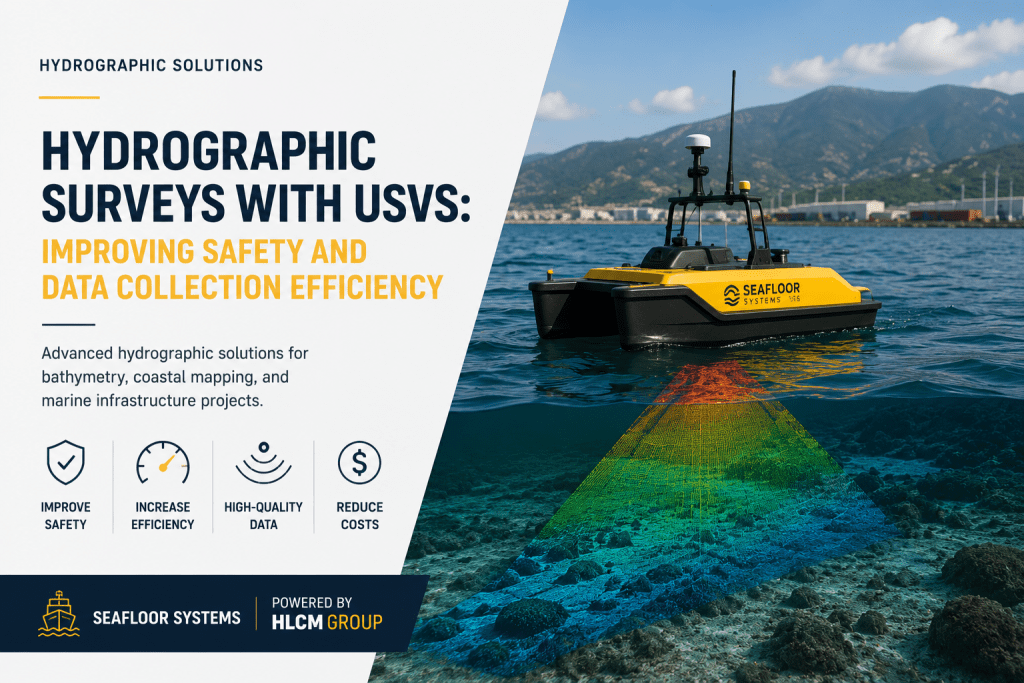
Hydrographic Surveys with USVs: Improving Safety and Data Collection Efficiency
Hydrographic surveying continues to evolve as organizations seek safer, faster, and more efficient methods for collecting underwater spatial data. Traditional vessel-based surveys often involve higher operational costs, larger field crews, and increased safety risks when working in shallow waters, reservoirs, rivers, ports, and coastal environments.
Unmanned Surface Vehicles (USVs) are transforming modern hydrographic operations by providing autonomous data collection capabilities while improving safety, reducing operational costs, and increasing survey productivity.
HLCM Group partners with Seafloor Systems to help organizations across Puerto Rico and the Caribbean implement advanced hydrographic workflows that combine autonomous navigation, sonar technology, and professional data processing for accurate bathymetric deliverables.
Why Use USVs for Hydrographic Surveys?
USVs allow survey teams to safely collect hydrographic information in areas that may be difficult, expensive, or hazardous for conventional survey vessels.
By minimizing the need for onboard personnel, autonomous survey vessels increase operational flexibility while maintaining exceptional data quality across a wide variety of marine environments.
Applications of USV Hydrographic Surveys
- Bathymetric surveys
- Coastal mapping
- Reservoir monitoring
- Harbor and port surveys
- River mapping
- Environmental monitoring
- Dredging projects
- Marine infrastructure inspections
- Water resource management
- Engineering studies
Improve Safety While Increasing Productivity
USV technology enables survey teams to operate efficiently in locations where traditional vessels may face operational limitations. Automated navigation and integrated sonar systems help reduce field time while increasing the consistency and quality of collected data.
Organizations adopting autonomous hydrographic workflows benefit from faster project completion, lower operational costs, and improved personnel safety.
Integrated Hydrographic Workflows with HLCM Group
HLCM Group helps organizations implement complete hydrographic workflows by integrating Seafloor Systems hydrographic solutions, advanced marine surveying technologies, Pix4D processing software, and modern geospatial workflows to maximize project efficiency.
Benefits of Autonomous Hydrographic Surveying
- Safer field operations
- Reduced survey costs
- Higher operational efficiency
- Accurate bathymetric data
- Improved coastal mapping
- High-quality sonar acquisition
- Reliable marine survey deliverables
- Efficient field-to-office workflows
Supporting Marine Projects Across Puerto Rico and the Caribbean
Whether supporting ports, environmental agencies, engineering firms, municipalities, or infrastructure developers, HLCM Group delivers modern hydrographic solutions tailored to each project's operational requirements.
From equipment selection to implementation and workflow optimization, our specialists help clients maximize the value of autonomous hydrographic technology while maintaining the highest standards of data quality.
Plan Your Hydrographic Survey with HLCM Group
Discover how USV technology and Seafloor Systems solutions can improve safety, accelerate bathymetric data collection, and optimize your hydrographic surveying workflow.